ILRMS Telangana TS Bhunaksha Map | Dharani portal map: The digitization of village maps is a commendable task by the government under the e-governance plan for the state of Telangana. Now a huge practice of digitizing the maps of almost all districts and villages is nearing completion and the maps can now be viewed online by the Department of State.
Village maps of all the villages (8,684) in the state of Telangana have been digitized and now these digital maps are publicly available on the official website of the Chief Commissioner for Land Administration (CCLA) for all people. The village map is also called Cadastral Map in Telangana. You can also check the digital cadastral map online through dharani Maa Bhoomi Telangana official website.
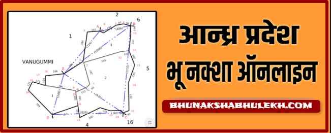
ILRMS Telangana Village Maps Maabhoomi CCLA Overview
| Article | ILRMS Village Map/ cadastral Map / Bhu Naksha Telangana |
| Started By | Telangana Government |
| Beneficiaries | Citizens of Telangana |
| Department | Chief Commissioner for Land Administration (CCLA) |
| Year | 2024 |
| Districts | All-districts |
| Main Objective | Providing Digital Map of Land/Village Map |
| Official website | https://ccla.telangana.gov.in/ or https://dharani.telangana.gov.in/gis/ |
District Wise TS Cadastral Map 2024
Find the list of districts in Telangana, Where you can search Village map TS, or Cadastral survey number Map / Bhu Naksha online. The list of Districts are given below:-
| Adilabad (ఆదిలాబాద్) | Nagarkurnool (నాగర్ కర్నూల్) |
| Bhadradri Kothagudem (భద్రాద్రి కొఠాగుడెం) | Nalgonda (నల్గొండ) |
| Hyderabad (హైదరాబాద్) | Narayanpet (నారాయణపేట) |
| Jagtial (జగిత్యాల ) | Nirmal (నిర్మల్) |
| Jangaon (జనగాం) | Nizamabad (నిజామాబాద్) |
| Jayashankar Bhupalpally (జయశంకర్ భూపాల్పల్లి) | Peddapalli (పెద్దపల్లి) |
| Jogulamba Gadwal (జోగులాంబ గద్వాల్) | Rajanna Sircilla (రాజన్న సిర్సిల్లా) |
| Kamareddy (కామారెడ్డి) | Rangareddy (రంగారెడ్డి) |
| Karimnagar (కరీంనగర్) | Sangareddy (సంగారెడ్డి) |
| Khammam (ఖమ్మం) | Siddipet (సిద్దిపేట) |
| Kumuram Bheem (కుమురాం భీమ్) | Suryapet (సూర్యాపేట) |
| Mahabubabad (మహబూబాబాద్) | Vikarabad (వికారాబాద్) |
| Mahabubnagar (మహబూబ్నగర్) | Wanaparthy (వనపర్తి) |
| Mancherial (మంచేరియాల్) | Warangal (Rural) (వరంగల్ (గ్రామీణ)) |
| Medak (మెదక్) | Warangal (Urban) (వరంగల్ (అర్బన్)) |
| Medchal (మేడ్చల్) | Yadadri Bhuvanagiri (యాదద్రి భువనగిరి) |
| Mulugu |
ILRMS Telangana Village Map, Cadastral Map Bhu Naksha
People of the state can now easily see the boundaries of village tanks, temples, prominent places, and land owned by the people within or near the villages by survey numbers of revenue units in digitized maps. The dreaded digital map of the state government has been made very easy so that even ordinary people without technical knowledge can easily see and understand it.
All the steps to get Village naksha Telangana online are mentioned below. Read all the steps carefully so that you do not face any problem in extracting the Village map/ Cadastral Map.
- Open the ccla.telangana.gov.in website. Or Click Here for Direct Link
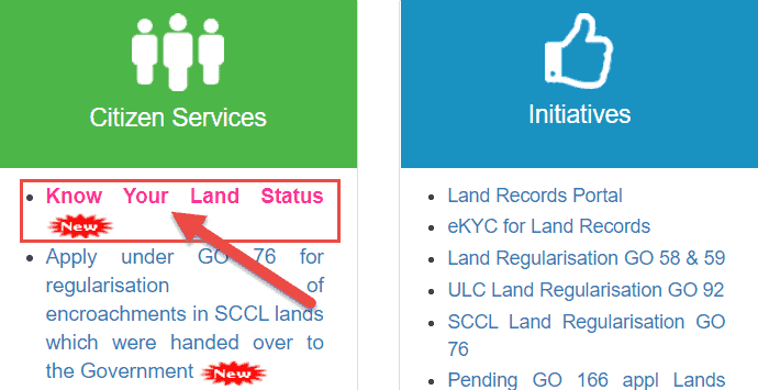
- Select the Know Your Land Status option – After the official website opens, different options will appear on the screen. Choose the option to “know your land status” from the option given here.
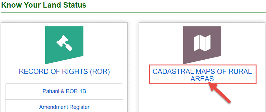
- Different options will be found on the next step screen. To get a village map, select the Cadastral Map Of Rural Areas option. As mentioned in the screenshot
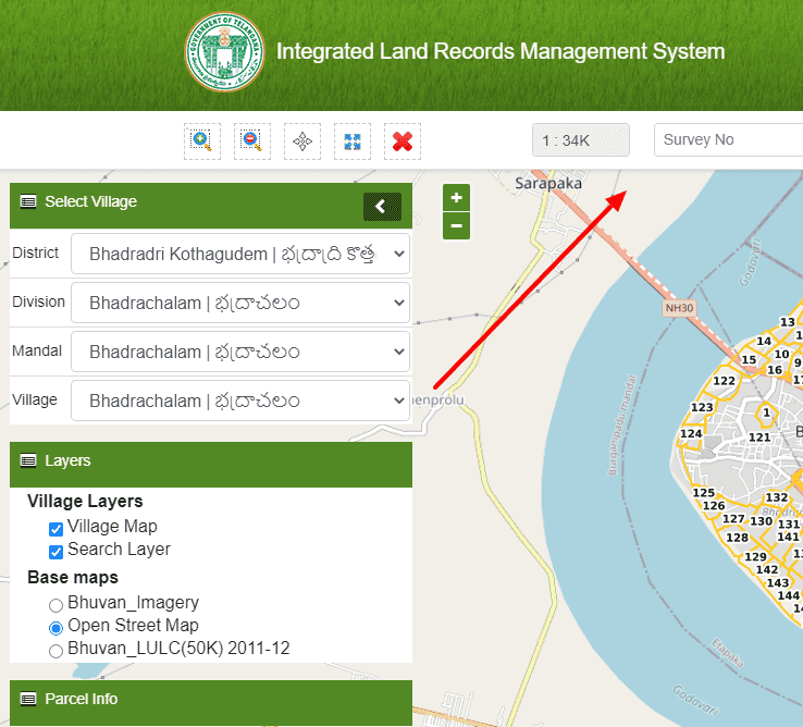
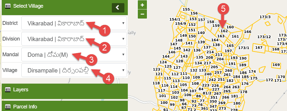
- Now select the district, division, Mandal, village to get a land map of your field plot. After this, the map will open on the right side. In this, select your land’s khata / survey number.
Telangana Village maps with survey numbers
- After submitting all the details, the record related to your land will appear on the left side. In this, select the view icon in front of whichever record you want to see.
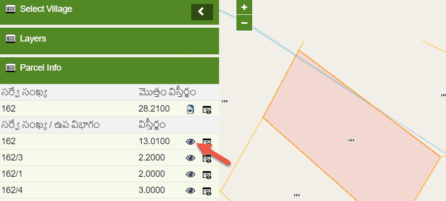
- As soon as you select the view icon, the land record of your land will appear on the screen. It can check all the important information. Also, you can download or print it.
Dharani Telangana Cadastral Map Online
If there is any problem in getting the land map Telangana on the official website of the maa Bhoomi Telangana / revenue department then you can check it on the dharani Telangana govt website as well. Let us also know about this.
- Open the dharani Telangana website –
Dharni TS Website:- First Open Integrated land records management system official portal to Get cadastral map/ Village map/ Bhunaksha Telangana. or Click to given link – dharani.telangana.gov.in
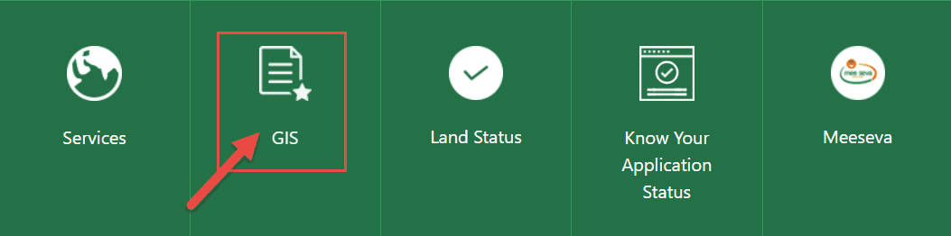
- Select the GIS option.
As soon as the official website of dharani Telangana is opened, different options will appear on the screen. Here GIS option will be found on the menu. Select this option to check the Telangana cadastral map record.
All further steps are the same as mentioned above. That is, select your district, division, Mandal, village and select the account number on the map. You can then extract the map details by viewing the desired record.
Telangana Bhunaksha Village Map App
To get the Telangana land map, no official i.e. official Android app has been made available yet. Yes, there are some apps in the Google Play Store but it is not an official app.
Therefore, to get the Telangana land map pahani record online one should use the official website of the Telangana government. You will get the right data on the official website or app itself.
Telangana Physical map of
You can get a digital map / Village map of your land in Telangana state. Which is used in many legal and other work. If you need a physical map, you can get it removed from such a tehsil or taluka office.
How to check the village map with survey numbers in Telangana?
Visit the Official website of ILRMS Telangana:- https://ilrms.telangana.gov.in/gis/
- The Bhu Naksha Telangana Portal Home Page will Open.
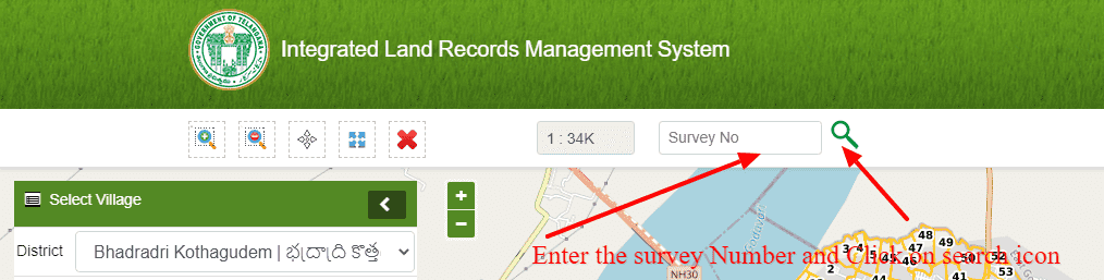
- Enter the survey Number and Click on the search icon
- If you do not know the survey number then please follow the step to get the village map of Telanagan by entering the basic details.

I need tippon of syno113of tirmalapur village cckunta mandal Mahabubnagar dist
cadastral maps with sy.no.with map not showing encumabarence search also not clear
District: Sangareddy
Mandal : Narayankhed
Village : Narsapur
There is no village map, can you please help how can i find ?
District janagon
Mandal= jangaon
Village = yellamla
My agriculture land edges missing please help me .other person occupied my land .please naksha map send my REQUEST
7661860837 call
the maps feature is not working in the dharani portal . plkease look into it
request your good office to restore old ccla website. It is very user friendly
District: Ranga Reddy
Mandal : Chevella
Village : Gundala and Laxmiguda
There is no village map, can you please help how can i find ?
thank you for Assam bhulekh information